Onsite Surveys:
Although archaeologists have been recording sites and landscapes using traditional surveying techniques for many years, advances in technology have enabled surveyors to map archaeology in real-time far more quickly and accurately than ever before. Our company provides the latest in surveying technology as described below:
GPS (Global Positioning System)
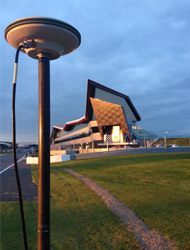
We use a Leica GPS Rover 1200 primarily to ensure that archaeological plans are georeferenced according to the Ordnance Survey National Grid. This is a standard requirement of archaeological specifications as issued by local authorities as a condition of planning consent. However, we also use GPS extensively in order to accurately map the position (and provide levels) of individual archaeological features and finds. This then allows us to produce highly accurate and detailed pre or post excavation site plans. Where required, we use GPS to set out site boundaries or evaluation trenches and have even used it to locate features seen from aerial photographs.
Total Station
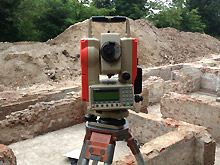
Where dense vegetation or buildings disrupt the satellite signal a total station is used to accurately map archaeological features producing the same detailed site plans as with GPS. We also use a total station to set out accurate site grids. In addition, we have used the total station to aid in the recording of historic buildings and walls to produce elevation drawings.
HDS (High Definition Scanning)
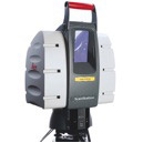
When recording above ground archaeology or archaeological sites of special importance, we can employ the use of a High Definition Scanner. This produces not only impressive, spatially accurate 3D visualisations, but also data for detailed contour mapping (see projects section for an example).
Offsite Digitising and Graphics Production:
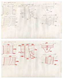
In addition to our onsite survey work, we use AutoCAD software to digitise hand drawn plans and sections that have been produced by archaeologists in the field. We do this by scanning and electronically ‘tracing’ them using CAD, thereby providing a digital copy of these drawings. Using standard archaeological drawing conventions, we produce scaled drawings (including site plans, phased plans and sections) for archaeological reports and publications. We can create PDFs of our graphics work and/or print paper copies at any scale or paper size. These may be laminated if desired.